East Sea Naming Dispute Enters New Phase as International Standard 'S-130' Is Adopted
Adoption of Digital Standard Managing Maritime Areas by Unique Numbers
East Sea vs. Sea of Japan Dispute Shifts to Competition Over Data Structures
As the international maritime labeling system shifts from using 'names' to 'numbers' with the adoption of a new digital standard, attention is now focused on future response strategies regarding the East Sea naming issue.
According to Yonhap News Agency on April 26, the International Hydrographic Organization (IHO) officially adopted the digital nautical chart standard 'S-130' during its 4th General Assembly, held in Monaco from April 19 to 23. This new framework replaces the existing nautical chart standard, 'Limits of Oceans and Seas (S-23),' and marks the completion of a next-generation system five years after its development was decided at the 2020 assembly.

The key feature of S-130 is the identification of maritime areas by unique numbers instead of names. Each sea area is assigned a numerical identifier based on latitude and longitude, designed for use in electronic navigation and geographic information systems. As a result, within the future IHO framework, all maritime areas will be managed by a unique identification number. The previously used S-23 will remain only as a reference material from the pre-digital era.
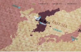
This adoption of the new standard intersects with the issue of the East Sea's name. Under the previous S-23 standard, only 'Sea of Japan' was used. South Korea has insisted that 'East Sea' be used alongside it, but the revision process stalled for years due to a lack of agreement between the two countries.
In this context, the introduction of S-130 is considered significant in that it shifts away from using names altogether. However, since it does not directly resolve the East Sea dual naming issue, a change in future strategy may be required. Experts believe the focus of competition has now moved from 'names' to 'data structures'.

Changkun Park, a professor at Kookmin University, told Yonhap News Agency, "The goal should now be to design a structure in which East Sea continues to be exposed," adding, "Rather than relying on diplomatic efforts for dual naming, it is important to ensure that the East Sea appears naturally within data standards and system design."
Hot Picks Today
 After Firing 1,000 $3.6 Million Missiles, U.S. ...
- [Breaking] Lee Jinsook Announces She Will Not Run for Daegu Mayor
- 'Man in His 20s Who Raped 14-Year-Old and Produced Sexually Exploitative Materia...
- "Seniors Take Over the Disco Festival: 'Only 50 and Above Allowed' [Mwonil Issyu...
- "We Can't Hold Out Any Longer": Airlines Reduce Seats, Cut Routes, and Face Bank...
He also stressed the need to cooperate with global platforms, noting that "the actual impact of place name labeling is determined by map services and maritime information platforms." He added, "It is essential to expand participation in international standard governance to gain influence at the structural design stage."
© The Asia Business Daily(www.asiae.co.kr). All rights reserved.