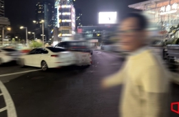
[One Day Ten Thousand Steps, One Day Thousand Characters] The Old Road of Hanyang, Starting at Gwanghwamun Station Exit 3
Seoul Museum of History 'Seoul History Exploration 7' Introduces 7 Exploration Routes
Market Street Starting from Gwanghwamun... Patrol Route Observing Curfew Era Markers
Scholar Hwang Yun-seok from Provinces, Commute from Sungkyunkwan to Changdong
![[One Day Ten Thousand Steps, One Day Thousand Characters] The Old Road of Hanyang, Starting at Gwanghwamun Station Exit 3](http://www.asiae.co.kr/news/img_view.htm?img=2023082410290450573_1692840544.jpg)
At Exit 3 of Gwanghwamun Station, turning around the Kyobo Building and entering Jongno, you will find the site marker of Hyejeonggyo Bridge. Hyejeonggyo Bridge marks the starting point of the marketplace and the intersection with Yukjo Street. At the Hyejeonggyo Bridge site marker, there is a restored Junghakcheon stream and a small tiled roof under Gwanghwamun D Tower. Below it, the remains of the Sijeon Haengrang (merchant quarters) are exhibited. Walking about two blocks from the Sijeon Haengrang site towards Jonggak Station, just before the Gran Seoul Building, you will find another tiled roof and a well site underneath. After visiting the Sijeon Haengrang remains path, passing through Bosingak and arriving at Tapgol Park, you can see the site marker of Gyeongsi Office in front. The Gyeongsi Office was a government agency overseeing the Sijeon and water-related matters. Inside Tapgol Park, there is the Ten-story Stone Pagoda of Wongaksa Temple Site, Changdeokgung Palace, and then you reach Gwangjang Market. The name “Gwangjang” is said to be derived from the first characters of Gwanggyo (Broad Bridge) and Janggyo (Long Bridge) of Cheonggyecheon Stream.
The Seoul Museum of History recently published “Seoul History Exploration Journal 7,” which contains experiences of historians and citizens exploring urban paths such as Jongno and Cheonggyecheon. The exploration journal is a grand project where historians and Seoul citizens have toured various parts of Seoul for ten years and publish an exploration journal annually; this is the seventh book. This journal introduces seven exploration routes under the theme “Walking the Roads of Hanyang.” The path introduced above is the first route, the Market Road. Since all goods and people gathered there, Hanyang had a representative market street called Unjongga. Named Unjongga (雲從街), meaning “street where people gather and disperse like clouds,” this road was planned and created with the birth of the capital Hanyang.

On July 21, 2022, the connecting passage between Changgyeonggung Palace and Jongmyo Shrine, which had been severed during the Japanese colonial period, was reopened. The view of the Changgyeonggung and Jongmyo connection road in Yulgok-ro, Jongno-gu, Seoul, is about to be opened to the general public. Photo by Jinhyung Kang aymsdream@
View original imageThe second route is the Patrol Road. During the Joseon Dynasty, there was a curfew from around 10 p.m. to 4 a.m., and those who enforced and patrolled it were called “Sunrakkun” (patrolmen). Today, the Patrol Road is known for its nostalgic old inns and hip cafes around Jongmyo Shrine. Following the footsteps of the Sunrakkun, you can also see site markers of government offices centered around Jongno, such as Podocheong (the police office), Uigeumbu (the royal investigation office that prosecuted noblemen’s crimes), and Jeonokseo (the prison also called “hell on earth”). Next to the markers, there are Catholic pilgrimage route signboards, marking sites of martyrdom. Traces of the Patrol Road remain at the site of U-Podocheong in front of Gwanghwamun Post Office, the Jeonokseo site in front of Exit 6 of Jonggak Station across from Bosingak, and the Uigeumbu site in front of Exit 1.
The third route is the commuting path of the scholar Hwang Yun-seok, who came to Seoul and served in government office. Hwang Yun-seok stayed at acquaintances’ houses, boarded near Sungkyunkwan in the Ban Village, or rented houses in the outskirts of the capital such as near Sugakgyo in Chang-dong. His commuting path is quite long even for those accustomed to walking.
![Donggwanwangmyo Shrine Panorama [Asia Economy DB]](http://www.asiae.co.kr/news/img_view.htm?img=2014051410541259588_1.jpg)
The fourth route is the Joseon Tongsinsa Road. While some officials commuted to government offices within the capital, there were also officials who embarked on journeys over 4,000 km long. These were the Joseon Tongsinsa envoys traveling between Joseon and Japan. From entering the palace to receiving royal orders, passing through Sungnyemun Gate, and reaching Yangjae Station, the gateway to the Yeongnam Road, this route traces the movements of the Joseon Tongsinsa in Seoul. After passing through Sungnyemun and exiting the capital, the envoys changed out of their official robes at Namgwanwangmyo and put on travel clothes for the journey. On the way to Yangjae Station, they held farewell parties with colleagues to check on each other’s well-being. Representative places include Jeonseongseo at the foot of Namsan Mountain, Itaewon, and Jecheonjeong in Hangganjin.
Hot Picks Today
 Even with High Oil Price Relief Payment, Additional 300,000 Won Per Person to Be Provided... Applications Open from the 18th in This Region
- "Invested 95% in Hynix and Reached 10 Billion Won"... Japanese Investor's Proof Post Goes Viral
- "Why Is the Korean Stock Market Surging?"... Even Italy Is Astonished by the KOSPI Rally
- "You Don't Need to Go to the Gym": The Best Exercises for Lowering Hypertension
- "That Thing Wakes Up Every Night" ... Suspicious Object Covers Rural Village
The fifth route is King Sukjong’s travel path. In 1691, King Sukjong went to pay respects at Jeongneung Royal Tomb. At that time, due to an epidemic, he stayed at Gyeongdeokgung Palace, so he started from there. Although Jeongneung was the closest royal tomb to the capital, it was not a distance that could be covered in one day. The king passed through Bojewon, Goam (today’s Anam), Sahari (today’s Mia-ri), and Suyu-ri to reach Jeongneung. The resting place, Jujeongso, was set up in Sahari. After paying respects at Jeongneung, King Sukjong completed military training including Yeolmusi at Sahari Gyojang, then on the way back to the palace, he stopped by Sesongcheon (Jeongneungcheon), Goam (Anam), Bojewon, and visited Donggwanwangmyo. Although Jeongneung and Donggwanwangmyo are places frequently visited in Seoul, exploring them while considering the symbolism and meaning related to King Sukjong’s royal procession adds deeper significance.

Citizens are walking along Cheonggyecheon Stream, a great place to walk in harmony with nature. Photo by Huh Younghan younghan@
View original imageThe sixth route is the Cheonggyecheon Stream path, a familiar urban resting place, also called King Yeongjo’s “Weemin Juncheon” (River Deepening for the People) path. This route embodies King Yeongjo’s will to carry out large-scale construction for the country. Today, Cheonggyecheon is mostly referred to in records as Gaechon (Open Stream). The stream passing through the center of the capital was an important drainage channel and, in the Joseon era without sewage facilities, a place where waste accumulated. King Yeongjo realized the river deepening project for the people living around the stream. Restored and opened in 2005, Cheonggyecheon has become a symbolic landmark of Seoul and an urban resting space. It is good to walk this path in a pleasant season while adding stories about King Yeongjo and history.
![A scene from the daily permanent festival held for tourists at Hwaseong Haenggung Palace in Suwon [Asia Economy DB]](http://www.asiae.co.kr/news/img_view.htm?img=2015032515524239286_1.jpg)
A scene from the daily permanent festival held for tourists at Hwaseong Haenggung Palace in Suwon [Asia Economy DB]
View original imageThe seventh route is King Jeongjo’s Filial Piety Road. This route extends from Hanyang to Suwon. In 1795, King Jeongjo celebrated his mother Lady Hyegyeong Hong’s 60th birthday by accompanying her to pay respects at the Hyeryungwon Tomb of his father Crown Prince Sado in Suwon. For this royal procession, instead of taking the usual route via Namtaryeong, he chose a relatively flat path towards Siheung. Rest stops called Jujeongso were set up every five ri (about 2 km) to provide spaces for his elderly mother to rest. The procession crossed the ferry installed at Noryangjin, then proceeded through Siheung Haenggung, Anyang Cham, Sageun Cham Haenggung, Jijidae, Manseokgeo, Yeonghwajeong, Suwon Hwaseong Fortress, Mannyeonje, Hyeryungwon, and Hwaseong Haenggung over eight days. Although places like Siheung Haenggung, Anyang Cham, and Sageun Cham Haenggung are now difficult to locate, exploring from the city center across Hangang Bridge towards Siheung and then to Suwon Hwaseong Fortress and Yunggeolleung Tomb offers a different enjoyment than just visiting Suwon Hwaseong alone.
© The Asia Business Daily(www.asiae.co.kr). All rights reserved.