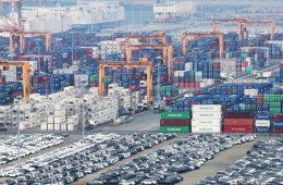
17% of the Entire Land Area is Urban, Housing 92% of the National Population

2019 Land Use Zoning Status (Provided by Ministry of Land, Infrastructure and Transport)
View original image[Asia Economy Reporter Chunhee Lee] Last year, urban areas nationwide accounted for 17% of the total land area. The population residing in urban areas was found to be 92% of the entire population.
The Ministry of Land, Infrastructure and Transport and Korea Land and Housing Corporation (LH) conducted a survey on the general status of urban areas as of last year, including population, area, zoning districts, zones, and urban and rural planning facilities, and announced the '2019 Urban Planning Status Statistics' on the 20th.
According to the statistics, urban areas designated as zoning districts under the 'National Land Planning and Utilization Act' covered 17,763 km², which is about 16.7% of the total designated land area of 106,210 km². The population residing in these areas was 47.59 million, accounting for 91.8% of the total registered population of 51.85 million.
Currently, the zoning districts of the entire land are composed of urban areas at 16.7% (17,763 km²), agricultural and forest areas at 46.4% (49,301 km²), management areas at 25.7% (27,260 km²), and natural environment conservation areas at 11,885 km² (11.2%), in order of proportion.
Among these, urban areas are further divided into green areas of 12,632 km² (71.1%), residential areas of 2,701 km² (15.2%), industrial areas of 1,219 km² (6.9%), commercial areas of 338 km² (1.9%), and undesignated areas of 874 km² (4.9%). The undesignated areas are adjacent reclaimed land (landfills) or industrial complexes connected to urban areas but not subdivided and designated separately.
Compared to 2018, all urban area categories showed slight increases: industrial areas by 20.7 km², residential areas by 16.8 km², commercial areas by 3.4 km², and green areas by 3.4 km². In Yeonsu-gu, Incheon, the existing reclaimed land was reduced, and zoning districts were reorganized, resulting in a decrease of 61.6 km² in undesignated areas.
The urban population was 47,596,532, representing 91.8% of the total population residing in urban areas. The proportion of urban residents has remained between 90% and 91% since surpassing 90% in 2005.
Development permits decreased by 14.4% from 305,214 cases in 2018 to 261,203 cases. Development permits are a system requiring administrative approval under the National Land Planning Act to prevent indiscriminate development and ensure planned land management.
Among these, 'building construction' accounted for the largest share with 157,452 cases (60.3%). This was followed by 'landform changes' with 68,389 cases (26.2%), 'land subdivision' with 24,536 cases (9.4%), and 'installation of structures' with 9,646 cases (3.7%). By metropolitan local government, Gyeonggi-do had the highest number with 66,302 cases, followed by Jeollanam-do with 26,632 cases and Gyeongsangbuk-do with 25,847 cases.
Hot Picks Today
 No Bacteria Detected in Arisu After 24 Hours of Repeated Drinking from a Tumbler
- "Not Even Expecting Gratitude, Just Hoping for No Complaints": Teachers' Sad Portrait on the Eve of Teacher's Day
- "Available Only in Korea": Pokémon Card Prices Surge 2,532% Due to Rarity, Becoming Investment Assets
- High-Net-Worth Investors Increase Stock Holdings: "Samsung and SK hynix Are Basic, Now Searching for the Next Opportunity" [Investment Strategies of the Wealthy] ⑧
- Police Officer Cycling on Day Off Rescues Woman Attempting to Jump from Hangju Bridge
The urban planning status statistics are compiled annually through local governments nationwide and are used as policy data for urban policy and planning formulation, local allocation tax calculation, and regional development planning. Detailed statistical data can be accessed via the Internet Urban Planning Information Service, Statistics Korea National Statistical Portal, Statistics Nuri, and e-Nara Indicators.
© The Asia Business Daily(www.asiae.co.kr). All rights reserved.