[Weather] Morning Cold Wind Drops Feels-Like Temperature... Raindrops in Jeju and South Coast

On the 3rd, citizens dressed in thick clothing hurried their steps to work at the Gwanghwamun intersection in Seoul. Photo by Mun Ho-nam munonam@
View original image[Asia Economy Reporter Lim Chunhan] On Friday the 5th, the whole country will be mostly clear, becoming cloudy from the afternoon. Jeju Island will see raindrops from the afternoon, and the southern coast will have raindrops starting at night. Expected precipitation is 5 to 10 mm.
The morning low temperature is forecasted to be between -9 and 1 degrees Celsius, and the daytime high temperature between 6 and 11 degrees Celsius. Due to cold air coming down from the northwest, some inland central areas will see morning lows around -10 degrees Celsius. Inland areas will also record temperatures around -5 degrees Celsius, and strong winds will make the perceived temperature even lower.
In the central region (excluding the east coast of Gangwon), eastern Jeonbuk, and northern inland Gyeongbuk areas, accumulated snow may freeze, making roads slippery. From this day until the early morning of the 6th, very strong winds with instantaneous speeds around 20 m/s are expected in the Gangwon mountain area, and a strong wind advisory may be issued.
In Gangwon Yeongdong and some parts of Gyeongsang where dry weather advisories have been issued, the atmosphere is dry and strong winds are blowing, so caution is needed to prevent fires such as wildfires.
Hot Picks Today
 "Stocks Are Not Taxed, but Annual Crypto Gains Over 2.5 Million Won to Be Taxed Next Year... Investors Push Back"
- "Don't Throw Away Coffee Grounds" Transformed into 'High-Grade Fuel' in Just 90 Seconds [Reading Science]
- Signed Without Viewing for 1.6 Billion Won... Jamsil and Seongbuk Jeonse Prices Jump 200 Million Won in a Month [Real Estate AtoZ]
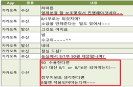
- [Breaking] President Lee: "Sharing operating profit before taxes are deducted?... I don't understand"
- "Even With a 90 Million Won Salary and Bonuses, It Doesn’t Feel Like Much"... A Latecomer Rookie Who Beat 70 to 1 Odds [Scientists Are Disappearing] ③
Sea waves will be 0.5 to 2 meters in the East Sea nearshore, 0.5 to 1.5 meters in the West Sea nearshore, and 0.5 to 1 meter in the South Sea nearshore. Offshore wave heights are expected to be 1 to 3 meters in the East Sea, 0.5 to 2 meters in the West Sea, and 0.5 to 2 meters in the South Sea.
© The Asia Business Daily(www.asiae.co.kr). All rights reserved.