Juwangsan National Park Ravaged by Wildfire
Even a water deer carcass found, fallen to the flames
Only one wildfire helicopter for all national parks
"Insufficient to contain large-scale fires"
"These trees must be at least 70 to 80 years old, and at this point, we have to assume even the standing ones are dead."
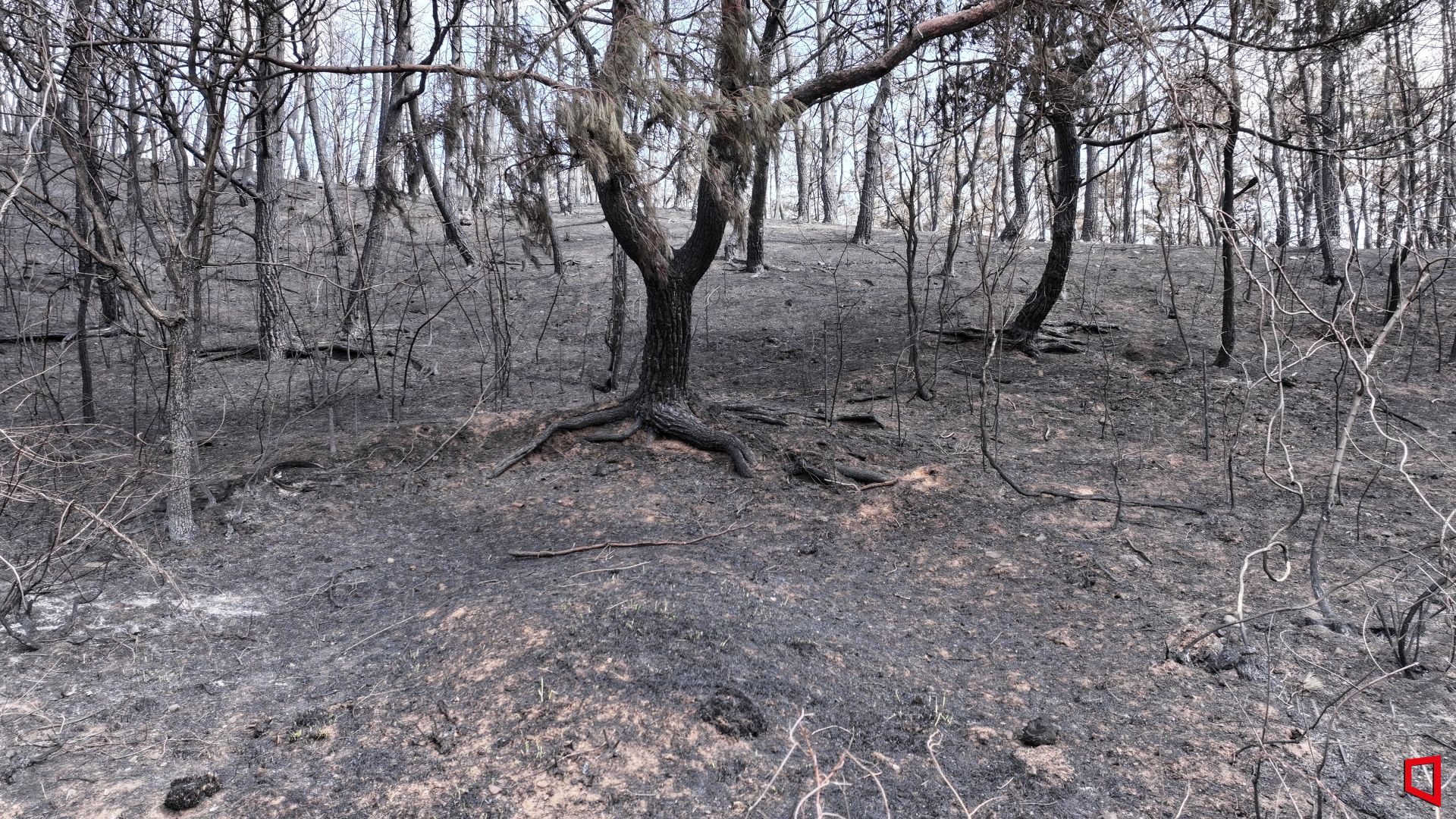
This was the bitter remark of a Korea National Park Service official I met at the foot of Juwangsan National Park in Cheongsong-gun, North Gyeongsang Province, at 12:05 p.m. on the 7th. Around this time of year, Juwangsan is normally filled with lush greenery, but on this day, the forest was charred black in many places. Areas once covered in undergrowth were now bare, with scorched, brittle soil exposed. Trees that had been engulfed in flames were left with only their barren stumps. Even the few trees still standing left black charcoal dust on your hand at the slightest touch. According to experts on site, most of the trees that still retained their shape had also lost their life.
National Park Shrouded in Ash, Greenery Gone

Traces left by the wildfire. A panoramic view of Juwangsan National Park in Cheongsong County, Gyeongbuk, on the 7th. Trees burned by the flames have turned ashen, revealing bare branches. Photo by Ministry of Environment Joint Press Corps
원본보기 아이콘
Traces left by the wildfire. A panoramic view of Juwangsan National Park in Cheongsong County, Gyeongbuk, on the 7th. Trees scorched by the flames have turned ashen, revealing bare branches. Photo by Ministry of Environment Joint Coverage Team
원본보기 아이콘Juwangsan is a mountain located in the Taebaek Mountain Range, which runs through central Korea, spanning Cheongsong-gun and Yeongdeok-gun in North Gyeongsang Province. It is home to endangered wild plants and species unique to the Korean Peninsula, and was designated a UNESCO Global Geopark in 2017, making it highly valuable for conservation. However, a wildfire that started in Uiseong, North Gyeongsang Province last month spread to Juwangsan, burning 3,260 hectares?11 times the size of Yeouido. This accounts for 20% of the entire Juwangsan National Park (16,000 hectares).
The extent of the damage was starkly visible from above. The coniferous forests, which make up 34% of Juwangsan, suffered the most. Conifers are vulnerable to wildfires, as sparks easily jump from tree to tree, making them more susceptible than broadleaf trees. While areas with broadleaf trees were scorched but retained much of their leaves and form, the coniferous forests were left with only bare, charred branches. The mountain was clearly divided into green and gray zones along the fire's path, making it look like two entirely different mountains.

Traces left by the wildfire. On the 7th, a roe deer presumed to have died in the fire was found lying at the foot of Juwangsan National Park in Cheongsong County, Gyeongbuk. Photo by Song Seungseop
원본보기 아이콘The wildfire damage was not limited to trees. In nearby villages, fire debris was still scattered, hinting at the extent of the disaster. Around the famous 'Dalgi Mineral Spring' in Juwangsan, melted slate-roofed houses and warehouses were left abandoned after being consumed by flames. On the road leading to the entrance of Juwangsan, the carcass of a water deer, presumed to have suffocated while trying to escape, was found. The 5.174-kilometer hiking trail was also engulfed, resulting in the loss of one visitor support center and 14 guide signs.
The park service explained that the damage was exacerbated by a shortage of firefighting helicopters. There is only one firefighting helicopter for all national parks nationwide. The model was first introduced in 1992, when the Russian government repaid a loan to Korea with helicopters. The park service intended to use the helicopter for the Juwangsan wildfire, but when the fire in Jirisan spread to residential areas, it was sent to Hadong-gun first. With the only helicopter dispatched to Jirisan, it became nearly impossible to contain the flames in Juwangsan.
Only One National Park Firefighting Helicopter... Equipment and Manpower Must Be Reinforced

Traces left by the wildfire. On the 7th, buildings and vehicles near Juwangsan National Park in Cheongsong County, Gyeongbuk, melted due to the fire. Photo by Ministry of Environment Joint Press Corps.
원본보기 아이콘
Traces left by the wildfire. A building near Juwangsan National Park in Cheongsong County, Gyeongbuk, melted by fire on the 7th. Photo by Ministry of Environment Joint Coverage Team.
원본보기 아이콘An Ho-kyung, head of the Juwangsan National Park Office, who was involved in the firefighting efforts, said, "When the fire was spreading, wind speeds reached 25 meters per second, making it difficult to even open a swinging door," and lamented, "Our personnel alone could not contain the main fire." He further pointed out, "If there had been one helicopter for each region?about four in total?we could have contained the fire more reliably. The current situation, where a single helicopter shuttles back and forth to fight fires, is not right."
The park service also emphasized the need to reinforce firefighting equipment and personnel to prevent wildfires in national parks. They estimate that 144 AI wildfire cameras are needed to monitor every part of the national parks without blind spots, and at least 18 high-performance wildfire trucks are required for initial response in lowland areas. An official from the Ministry of Environment stated, "If the government passes a supplementary budget, we will actively pursue projects to reinforce firefighting equipment."

On the 7th, employees of the Korea National Park Service were conducting work to assess the scale of fire damage at Juwangsan National Park in Cheongsong County, Gyeongbuk. Photo by Song Seungseop
원본보기 아이콘Official Damage Assessment Underway... Analysis to Continue Until Year-End
Meanwhile, an official investigation to accurately assess the damage began in earnest on the 7th. The Korea National Park Service formed a team comprising 17 researchers from the National Park Research Institute, 2 from the Wildlife Conservation Center, and 27 from the Ecosystem Survey Team to calculate the extent and nature of the ecological damage. On this day, eight investigators at Juwangsan split into two teams and climbed steep, unpaved mountain paths. Using measuring tapes, they checked how high the flames had reached on the trees and drilled into trunks to determine the age of damaged trees by counting rings. They also dug up soil samples to analyze the microorganisms, in an effort to determine whether the forest could recover naturally.
It is expected to take considerable time to finalize the total damage. The park service plans to complete all basic field surveys by the 10th, after which they will assess the damage to biological resources and the natural recovery potential of the vegetation starting next month. A total of 47 experts across 21 teams will conduct a detailed assessment of Juwangsan in nine categories. If the analysis process is delayed, it may continue until December.
An 'Emergency Restoration Plan for the Ecological Sector' will be implemented in the affected areas. According to the plan, the park service will collect and propagate seeds of dominant species in preparation for restoration. In the case of Juwangsan, this includes Quercus variabilis, Fraxinus rhynchophylla, Quercus mongolica, Carpinus tschonoskii, and Pinus densiflora. To support birds that lost their habitats due to the wildfire, artificial nests will be installed, and temporary food sources such as hay will be placed at the park's boundaries to improve living conditions. For hiking trails, all available resources will be mobilized to reopen them before the rainy season in June.
IndexRefo
- "Only One Wildfire Helicopter Available, Firefighter Sighs: 'If Only There Had Been More...'"
- Finally in My Hands... Limited Edition 'Labubu' Goods Arrive in Korea, Fans Snap Photos
- It Takes Three Hours at Incheon Airport... Istanbul's 'Fast Track' Finishes in Just Five Minutes
-

Reporter Song Seungseop tmdtjq8506@asiae.co.kr
-
Edit Kim Yumi ymkim91@asiae.co.kr
© The Asia Business Daily(www.asiae.co.kr). All rights reserved.


![[Culture Interview] "Unifying the Fragmented Music Market... Super Fans Are the Next Competitive Edge"](https://cwcontent.asiae.co.kr/asiaresize/304/2026042817051344090_1777363513.jpg)