[Tomorrow's Weather] Typhoon 'Haishen' Impact Zone... Strong Rain and Wind Nationwide
![[Image source=Yonhap News]](http://www.asiae.co.kr/news/img_view.htm?img=2020090620000565331_1599390005.jpg)
[Asia Economy Reporter Seongpil Cho] On Monday the 7th, due to the influence of Typhoon No. 10 'Haishen,' heavy rain and strong winds are expected nationwide.
According to the Korea Meteorological Administration on the 6th, Typhoon Haishen is expected to move northward to about 80 km northeast of Busan by around 9 a.m. the next day. Heavy rainfall of 100 to 300 mm is expected mainly in Gangwon Yeongdong and Gyeongsang provinces, which are close to the typhoon's path. Some areas may experience torrential rain exceeding 400 mm. Additionally, Jeollanam-do, eastern inland Jeollabuk-do, and Jeju Island are expected to receive 100 to 200 mm of rain, while the mountainous areas of Jeju Island, Jirisan, and Deogyusan are forecasted to have rainfall exceeding 300 mm. Other regions are expected to receive 50 to 100 mm of rain. The rain will gradually stop from the southern regions during the night.
In Gangwon Yeongdong, Gyeongsang provinces, and Jeju Island, maximum instantaneous wind speeds of 25 to 40 m/s are expected, while the west and south coasts will experience strong winds of 10 to 30 m/s. Ulleungdo and Dokdo, located in the typhoon's dangerous semicircle, may experience very strong winds exceeding 50 m/s. The Korea Meteorological Administration urged thorough preparation to prevent secondary damage caused by the destruction of outdoor facilities such as screening clinics, wind turbines, and transmission towers due to strong winds.
The morning low temperature is forecasted to be between 17 and 24 degrees Celsius, and the daytime high temperature between 21 and 28 degrees Celsius. Due to smooth atmospheric dispersion and the influence of precipitation, fine dust levels are expected to be 'Good' across all regions.
Hot Picks Today
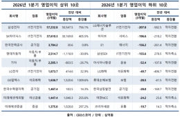
 "Now Our Salaries Are 10 Million Won a Month" Record High... Semiconductor Boom Drives Performance Bonuses at Major Electronic Component Firms
- Experts Already Watching Closely..."Target Price Set at 970,000 Won" Only Upward Momentum Remains [Weekend Money]
- "Heading for 2 Million Won": The Company the Securities Industry Says Not to Doubt [Weekend Money]
- 'Still Hesitant? If You're Wondering Whether KOSPI Will Rise, This Is the Number You Must Watch [Weekend Money]'
- Is It Really Like an Illness? "I Can't Wait to Go Again"—Over 1 Million Visited in Q1, Now 'Busanbyeong' Takes Hold [K-Holic]
Along the southern coast, Jeju Island, and the east coast, sea levels are expected to rise about 1 meter higher than usual as the typhoon approaches. There is concern about damage and flooding of coastal facilities due to storm surges, so special caution is required to prevent damage. Waves at sea will reach heights of 1.5 to 5.0 meters in the West Sea, 4.0 to 10.0 meters in the South Sea, and 2.0 to 12.0 meters in the East Sea. Offshore wave heights are forecasted to be 2.0 to 8.0 meters in the West Sea and 3.0 to 12.0 meters in the South and East Seas.
© The Asia Business Daily(www.asiae.co.kr). All rights reserved.