[Tomorrow's Weather] Nationwide Typhoon 'Maysak' Impact... Seoul Metropolitan Area to Receive 50mm Per Hour Downpour

On the 27th, as the 8th typhoon 'Bavi' moved northward along the west coast, citizens in Yeouido, Seoul, hurried along with umbrellas. The Korea Meteorological Administration forecasted that although the area would be out of the typhoon's influence that day, rain would continue across most regions nationwide until the 29th due to a pressure trough approaching from the southwest. Photo by Kim Hyun-min kimhyun81@
View original image[Asia Economy Reporter Dongwoo Lee] On Thursday, the 3rd, due to the influence of Typhoon No. 9 'Maysak', the entire country will be cloudy with strong winds and heavy rain.
Expected rainfall amounts are 100 to 300 mm in Gangwon Yeongdong, the east coast of Gyeongbuk, Gyeongnam, Jeonnam, eastern Jeonbuk, and Jeju Island, with some areas receiving over 400 mm of rain.
Seoul, Gyeonggi-do, Gangwon Yeongseo, Chungcheong Province, and Gyeongbuk will see 100 to 200 mm, while southern Chungnam and Jeonbuk will have 50 to 150 mm. Rain will fall in Jeju Island until morning, in the southern regions until the morning, and in the central regions until the afternoon.
In Seoul and Gyeonggi-do, from dawn to morning, there will be very heavy rain of about 50 mm per hour accompanied by gusts and thunder and lightning in some areas.
The southern coast, east coast, and coastal areas of Jeju Island should be cautious of storms and tidal waves. Especially in some areas of the Gyeongsang coast, when the typhoon center is closest, instantaneous wind speeds exceeding 180 km/h with very strong winds are expected, so thorough preparation is necessary to prevent damage to facilities.
Tomorrow morning's lowest temperature is expected to be 20 to 26 degrees Celsius, and the highest temperature during the day is expected to be 25 to 32 degrees Celsius.
Hot Picks Today
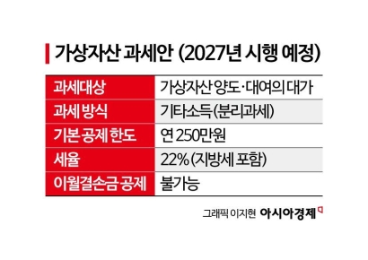 "Stocks Are Not Taxed, but Annual Crypto Gains Over 2.5 Million Won to Be Taxed Next Year... Investors Push Back"
- "Not Jealous of Winning the Lottery"... Entire Village Stunned as 200 Million Won Jackpot of Wild Ginseng Cluster Discovered at Jirisan
- "Even With a 90 Million Won Salary and Bonuses, It Doesn’t Feel Like Much"... A Latecomer Rookie Who Beat 70 to 1 Odds [Scientists Are Disappearing] ③
- "Rather Than Endure a 1.5 Million KRW Stipend, I'd Rather Earn 500 Million in the U.S." Top Talent from SNU and KAIST Are Leaving [Scientists Are Disappearing] ①
- "How Did an Employee Who Loved Samsung End Up Like This?"... Past Video of Samsung Electronics Union Chairman Resurfaces
Sea waves will be 2 to 10 meters in the East Sea nearshore, 1 to 4 meters in the West Sea nearshore, and 1 to 10 meters in the South Sea nearshore. Wave heights in the open sea are expected to be 3 to 12 meters in the East Sea, 2 to 7 meters in the West Sea, and 2 to 12 meters in the South Sea.
© The Asia Business Daily(www.asiae.co.kr). All rights reserved.