Typhoon That Hit Jeju Moves to Gyeongnam Coast at Dawn... Strong Rain and Wind in Seoul Tomorrow
Typhoon Maysak No. 9 Moving North
Developing into a Very Strong Typhoon
120 km/h Winds at Jiguido, Seogwipo, Jeju
238.5 mm Rainfall Recorded in Sajebi Area, Hallasan
![On the afternoon of the 2nd, when Typhoon Maysak, the 9th typhoon, struck Jeju, street trees on Yeonsam-ro in Ido 2-dong, Jeju City, were knocked down by the typhoon, and public officials were moving the trees and taking safety measures. [Image source=Yonhap News]](http://www.asiae.co.kr/news/img_view.htm?img=2020090216194559271_1599031186.jpg)
On the afternoon of the 2nd, when Typhoon Maysak, the 9th typhoon, struck Jeju, street trees on Yeonsam-ro in Ido 2-dong, Jeju City, were knocked down by the typhoon, and public officials were moving the trees and taking safety measures. [Image source=Yonhap News]
View original image[Asia Economy Reporter Hyunju Lee] Typhoon Maysak, the 9th typhoon, passing over the sea near Seogwipo, Jeju, is moving northward while bringing very strong winds and heavy rainfall.
According to the Korea Meteorological Administration, as of 3 PM on the 2nd, the typhoon is moving north-northeast at 19 km/h about 190 km south-southeast of Seogwipo. The central pressure is 945 hPa, and the maximum wind speed is 162 km/h (45 m/s), indicating it has developed into a very strong typhoon.
Regarding the maximum instantaneous wind speeds at major locations, 120 km/h was recorded at Jiguido, Seogwipo, 102 km/h in Jeju, and 97 km/h in Udo. The Sasebi area of Hallasan Mountain received rainfall reaching 238.5 mm.
Typhoon warnings are in effect for all seas around Jeju Island, the southern Yellow Sea, the southern sea, and the southern East Sea. Strong winds with maximum instantaneous wind speeds around 120 km/h (33 m/s) are expected in Jeju Island and the southern coast. Heavy rain advisories are issued for parts of Gyeongsangbuk-do and Gangwon Yeongdong, where heavy rain exceeding 30 to 60 mm per hour is expected.
The typhoon is forecasted to pass the coast of Gyeongnam and make landfall on the southern coast around 1 AM on the 3rd. It is expected to pass inland between Geoje and Busan, with Busan experiencing the closest approach around 2 AM on the 3rd.

Typhoon Maysak No. 9 Notification as of 3 PM on the 2nd (Provided by the Korea Meteorological Administration website)
View original imageAreas near the typhoon’s path, including Gangwon Yeongdong, the eastern coast of Gyeongbuk, Gyeongnam, Jeonnam, eastern Jeonbuk, and Jeju Island, are expected to receive 100 to 300 mm of rain by the 3rd, with especially heavy rainfall exceeding 400 mm expected in Gangwon Yeongdong, the eastern coast of Gyeongsang, and the mountainous areas of Jeju Island. Particularly, during the period of high astronomical tides (spring tide), the northward movement of the typhoon combined with meteorological tides may cause storm surges along the southern coast, eastern coast, and Jeju coastal areas, requiring preparedness.
Hot Picks Today
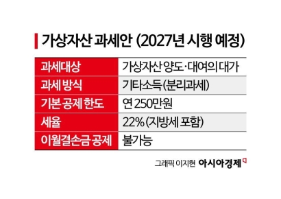 "Stocks Are Not Taxed, but Annual Crypto Gains Over 2.5 Million Won to Be Taxed Next Year... Investors Push Back"
- "Not Jealous of Winning the Lottery"... Entire Village Stunned as 200 Million Won Jackpot of Wild Ginseng Cluster Discovered at Jirisan
- "Even With a 90 Million Won Salary and Bonuses, It Doesn’t Feel Like Much"... A Latecomer Rookie Who Beat 70 to 1 Odds [Scientists Are Disappearing] ③
- "Rather Than Endure a 1.5 Million KRW Stipend, I'd Rather Earn 500 Million in the U.S." Top Talent from SNU and KAIST Are Leaving [Scientists Are Disappearing] ①
- "How Did an Employee Who Loved Samsung End Up Like This?"... Past Video of Samsung Electronics Union Chairman Resurfaces
From dawn to morning on the 3rd, Seoul and Gyeonggi Province may experience very heavy rain of about 50 mm per hour accompanied by gusts and thunder and lightning, so special caution is needed to prevent damage. The expected rainfall amount is 100 to 200 mm.
© The Asia Business Daily(www.asiae.co.kr). All rights reserved.