Yangpyeong County and LX Sign Digital Spatial Information MOU to Implement Smart Administration
Yangpyeong County and LX Strengthen Cooperation in Advanced Spatial Information
Protecting Residents' Property Rights with Accurate Spatial Data
Expanding Private Sector Utilization through Digital Spatial Information Collaboration
Yangpyeong County in Gyeonggi Province (Governor Jin Jinseon) signed a Memorandum of Understanding (MOU) with LX Korea Land and Geospatial Informatix Corporation (President Eom Myungso) on the 10th to establish a digital spatial information cooperation system, aiming to expand smart administrative services that residents can directly experience.

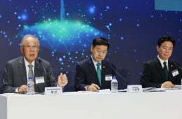
Jin Jinseon, Yangpyeong County Governor (right), signed a Memorandum of Understanding (MOU) for the establishment of a digital spatial information cooperation system with Eom Myungso, President of LX Korea Land and Geospatial Informatix Corporation, on the 10th. Provided by Yangpyeong County
View original imageThe signing ceremony was held in the governor’s office on the second floor of Yangpyeong County Hall, attended by Jin Jinseon, Governor of Yangpyeong County, Lee Juhwa, Vice President of LX, and other key officials from both organizations.
This agreement aims to establish a cooperative framework based on digital spatial information and to provide more accurate and reliable land information through the maintenance of continuous cadastral maps and continuous thematic maps.
The main points of the agreement include: △ Establishing and streamlining an administrative cooperation system based on digital spatial information △ Strengthening the protection of property rights through the maintenance of continuous cadastral and thematic maps △ Precise management of three-dimensional spatial data using advanced surveying technologies such as drones and LiDAR △ Enhancing resident convenience by developing lifestyle-oriented spatial information services.
Through this agreement, Yangpyeong County plans to reduce inconvenience for landowners by providing more accurate cadastral information and to utilize advanced spatial data in various administrative fields such as construction and disaster response.
In addition, spatial information held by the public sector will be made available to the private sector, allowing all residents to use map-based data. This will make it easier to check land information and prevent disputes, and residents will be able to conveniently access essential information for daily life through location-based spatial data.
Hot Picks Today
Jin Jinseon, Governor of Yangpyeong County, stated, "This agreement will enhance administrative efficiency based on spatial information and contribute to protecting residents’ property rights," adding, "We will work with LX Korea Land and Geospatial Informatix Corporation to build a sustainable digital spatial information cooperation system where both the public and private sectors can grow together."
© The Asia Business Daily(www.asiae.co.kr). All rights reserved.