ICEYE Calls for Integrated Surveillance System Using Ultra-Small Satellites
South Korean Military Launches Four Reconnaissance Satellites as Part of 425 Project
Surveillance Gaps Inevitable Without Ultra-Small Satellites
U.S. Military Implements Multi-Layered Surveillance by Integrating Commercial Satellites
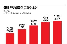
The South Korean military is currently advancing its reconnaissance satellite program (425 Project), a core asset of the Korean-style Kill Chain, to strengthen surveillance and reconnaissance capabilities. The project involves an investment of approximately 1.22 trillion won to deploy five reconnaissance satellites: four equipped with high-performance Synthetic Aperture Radar (SAR) and one equipped with Electro-Optical (EO) and Infrared (IR) sensors. The first three satellites have already been deployed for operations, and a surveillance system will be established by combining various sensors such as EO, IR, and SAR. The military is currently conducting operational test evaluations for the fourth satellite, which was launched in April, and plans to launch the final military reconnaissance satellite within this year. Recently, Finnish satellite monitoring company ICEYE proposed a project to enhance real-time surveillance by integrating the South Korean military's satellites with its own satellite network, claiming that this would enable a denser surveillance system.

Once the 425 Project is completed, the reconnaissance satellites will monitor the Korean Peninsula from altitudes of 300 to 1,000 kilometers above ground. Each satellite will pass over North Korea and capture images every two hours. SAR satellites emit radio waves toward the ground, receive the reflected signals, and synthesize them to create images. By combining thousands of pulses, they produce high-resolution images and can operate both at night and in adverse weather conditions. Notably, they are highly effective at identifying metallic objects, making it possible to detect radar systems, missiles, and tanks hidden under camouflage or foliage. EO satellites capture direct images of the ground using visible light, providing images with high clarity and readability, but are limited by weather conditions. IR satellites obtain images using infrared sensors based on the thermal characteristics of objects. By accumulating and matching images transmitted from each satellite, the accuracy of analysis can be significantly improved.
South Korean Military Launches Four Reconnaissance Satellites as Part of 425 Project
The main issue is the surveillance gap. Even with all five reconnaissance satellites deployed, the South Korean military can only monitor the skies over the Korean Peninsula every two hours. During this interval, North Korea's mobile missile launchers can move between 40 and 60 kilometers. Therefore, relying solely on reconnaissance satellites is insufficient for monitoring North Korea. In response to continued provocations from North Korea in 2017, the Reconnaissance Satellite Project Team at the Ministry of National Defense also attempted to lease reconnaissance satellites from Israel, France, and Germany. The aim was to independently secure satellite imagery of sites such as the Punggye-ri nuclear test facility and the Dongchang-ri missile launch site. However, due to issues such as orbital compatibility and leasing costs, the negotiations did not progress, and the leasing project was ultimately abandoned.
ICEYE argues that the introduction of small satellite information services is urgently needed to reduce surveillance gaps. Jin Yong Lee, Executive Director of ICEYE, who oversees the Korean business (pictured), emphasized, "By combining the mid-sized satellites launched by the South Korean military with ICEYE's SAR satellites, it is possible to secure stable imagery of any region on Earth." He further stated, "ICEYE has launched the largest number of SAR small satellites among satellite companies, with 54 satellites already in orbit, enabling stable imagery for any region on the planet. By the end of 2027, the cumulative number of satellites launched is expected to reach approximately 100."
Surveillance Gaps Inevitable Without Ultra-Small Satellites
The South Korean military is also pursuing the development of an ultra-small satellite system, aiming to secure around 30 satellites weighing approximately 100 kilograms each by 2030. If the Agency for Defense Development (ADD) successfully deploys 32 ultra-small SAR satellites currently under development, the area surrounding the Korean Peninsula could be monitored at 30-minute intervals. This would allow the preemptive detection of movements by North Korea's mobile launchers (TEL) used to covertly launch nuclear-armed missiles. Small satellites are capable of observing objects as small as one meter from an altitude of 510 kilometers. The mass production cost per satellite is expected to be in the range of 7 to 8 billion won. The military believes that since Hanwha Systems, a domestic defense company, has succeeded in developing AESA radar for the Korean next-generation fighter jet (KF-X), the time and cost required to develop SAR radar for ultra-small satellites can be significantly reduced.
However, if the probability of successful satellite launches is low or development is delayed, surveillance gaps will be inevitable. Lee emphasized, "ICEYE goes beyond simply collecting and providing imagery. Field commanders can request surveillance of specific areas, and high-resolution images obtained within a few hours can be used to issue operational orders, which will inevitably enhance the South Korean military's Kill Chain capabilities."
U.S. Military Implements Multi-Layered Surveillance by Integrating Commercial Satellites
Other countries are also operating systems that combine existing reconnaissance satellites with ICEYE's satellites. The U.S. Department of Defense has recently adopted commercial satellites for parallel operation with military satellites. These are managed by the U.S. Space Command and the National Geospatial-Intelligence Agency (NGA), and have been evaluated as superior in terms of mobility, responsiveness, and cost efficiency. Lee explained, "ICEYE's Tactical Access capability becomes possible when ground stations, antennas, and automated processing systems are integrated. This concept has already been validated by organizations such as NATO and the U.S. Department of Defense."
Hot Picks Today
 "Could I Also Receive 370 Billion Won?"... No Limit on 'Stock Manipulation Whistleblower Rewards' Starting the 26th
- Samsung Electronics Introduces New "Special Performance Bonus" for Semiconductors, Paid Entirely in Company Shares
- "From a 70 Million Won Loss to a 350 Million Won Profit with Samsung and SK hynix"... 'Stock Jackpot' Grandfather Gains Attention
- "US-Iran: Patch-Ups More Likely Than Settlement... Unlikely to Resolve Within 6 Months" [Economic Policy Zoom-In]
- "Who Is Visiting Japan These Days?" The Once-Crowded Tourist Spots Empty Out... What's Happening?
Some countries receive battlefield information directly through ICEYE's satellites. Ukraine is one such example. During the war in 2022, Ukraine decided to purchase one of ICEYE's operational satellites in orbit. Over the two-year duration of the war, the Ukrainian Defense Intelligence Directorate (HUR) collected target information more than 4,600 times on the locations of Russian troops, military supplies, air bases, ports, and key infrastructure. Former Ukrainian Defense Minister Oleksii Reznikov stated on social media, "The damage inflicted on Russian forces in just two days exceeded the amount we spent on acquiring the satellite. More importantly, countless lives have been saved, which is something that cannot be measured in monetary terms."
© The Asia Business Daily(www.asiae.co.kr). All rights reserved.