Oh Se-hoon Launches Full-Scale Promotion of 'National Symbolic Street' from Gwanghwamun to Hangang... Reducing Roads and Increasing Garden Green Spaces
Site Visit to Paris 8th District's 'Champs-?lys?es Street and Place de la Concorde' Urban Green Axis Creation Area
Boldly Reducing Car Lanes and Increasing Garden Greenery by 2030 to Create Streets for People and Nature
Full-Scale Promotion of 'National Symbolic Boulevard' Linked to Gwanghwamun Square... Reducing Car Lanes from Seoul Station to Han River for Pedestrian and Green Spaces

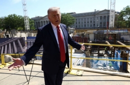
[Asia Economy Reporter Lim Cheol-young] On the afternoon of the 22nd local time, Seoul Mayor Oh Se-hoon visited the ‘Paris 8th District Urban Green Axis Creation’ site and revealed plans to reorganize major streets in Seoul, including the ‘National Symbolic Boulevard’ connecting Gwanghwamun~Seoul Station~Yongsan~Han River, into green ecological streets.
The ‘Paris 8th District Urban Green Axis Creation’ is a project to renovate the Champs-?lys?es and Place de la Concorde, iconic landmarks of France, into an urban green axis rich in history and culture and a garden for citizens by 2030. The eight-lane road, which used to carry over 60,000 vehicles daily, will be boldly reduced to four lanes, while creating abundant resting spaces and greenery for pedestrians.
This project was announced in 2020 by Anne Hidalgo, the Mayor of Paris. In response to criticism that the Champs-?lys?es, a representative landmark of Paris, had become a center of exhaust fumes and consumption, 330 billion KRW is being invested to transform it into a people- and nature-centered street and a vast garden for citizens.
Mayor Oh listened to the ‘Paris 8th District Urban Green Axis Creation’ project plan from Paris city officials and toured the site together at the Champs-?lys?es located in the heart of Paris. The city expects to find solutions to restore the identity of the national central boulevard, whose significance has faded due to rapid urbanization, by drawing on the Champs-?lys?es and Place de la Concorde project, which shares many similarities with the ‘National Symbolic Boulevard’ in terms of historicity and sense of place.
Seoul is also promoting the creation of linear parks throughout the city center and restructuring spaces to organically connect green spaces across Seoul, including actively developing the ‘National Symbolic Boulevard’ in connection with the reopened ‘Gwanghwamun Square.’ First, the ‘National Symbolic Boulevard’ is a 7km section connecting Gwanghwamun~Seoul Station~Yongsan~Han River, representing Seoul’s history and culture. The goal is to elevate the status of this space as Seoul’s representative symbolic area, similar to Paris’s Champs-?lys?es, and to extend the vitality starting from Gwanghwamun Square to the Han River.
In connection with the ‘National Symbolic Boulevard,’ the city completed the ‘Sejong-daero People’s Forest Path’ in May last year, covering a 1.55km section from Sejong-daero Intersection~Sungnyemun~Seoul Station. The number of lanes was reduced from 9-12 to 7-9, and pedestrian space more than twice the size of Seoul Plaza was created. A new bicycle path was added along the entire Sejong-daero. Various trees such as zelkova, hackberry, and elm have been planted throughout the street, receiving great public approval.
Starting this year, the project will be actively pursued for the 5.3km section from Seoul Station through Yongsan to the Han River. The number of lanes on the Seoul Station~Hangang-daero section (4.2km) will be reduced (from 6-9 lanes to 4-6 lanes), while the narrow and inconvenient pedestrian paths will be expanded up to 1.5 times in width, and new bicycle paths will be installed. Pedestrian environments will be improved in areas with interrupted pedestrian flow, such as in front of Seoul Station Plaza, by adding new crosswalks.
In addition, Seoul is also promoting the ‘National Assembly Boulevard Upper Park Project.’ This involves undergrounding ‘National Assembly Boulevard’ (7.6 km from Sinwol IC to National Assembly Intersection), which has served as Korea’s first expressway and a car-only road for over 50 years, and creating a large-scale linear park of about 110,000㎡ on the surface.
Hot Picks Today
!["Rather Than Endure a 1.5 Million KRW Stipend, I'd Rather Earn 500 Million in the U.S." Top Talent from SNU and KAIST Are Leaving [Scientists Are Disappearing] ①](https://cwcontent.asiae.co.kr/asiaresize/93/2026051914165468840_1779167814.png) "Rather Than Endure a 1.5 Million KRW Stipend, I'd Rather Earn 500 Million in the U.S." Top Talent from SNU and KAIST Are Leaving [Scientists Are Disappearing] ①
"Rather Than Endure a 1.5 Million KRW Stipend, I'd Rather Earn 500 Million in the U.S." Top Talent from SNU and KAIST Are Leaving [Scientists Are Disappearing] ①
- "Not Jealous of Winning the Lottery"... Entire Village Stunned as 200 Million Won Jackpot of Wild Ginseng Cluster Discovered at Jirisan
- "I'll Stop by Starbucks Tomorrow": People Power Chungbuk Committee and Geoje Mayoral Candidate Face Criticism for Alleged 5·18 Demeaning Remarks
- "Stocks Are Not Taxed, but Annual Crypto Gains Over 2.5 Million Won to Be Taxed Next Year... Investors Push Back"
- "How Did an Employee Who Loved Samsung End Up Like This?"... Past Video of Samsung Electronics Union Chairman Resurfaces
Seoul City stated, "We will create a ‘pedestrian-friendly green city, Seoul’ where citizens can enjoy green leisure culture anywhere in Seoul by linking various park green paths such as the National Symbolic Boulevard, Sejong-daero People’s Forest Path, and National Assembly Boulevard Upper Park, as well as urban infrastructure like underpasses of overpasses, underground walkways, and existing landmarks such as the Seoul Trail."
© The Asia Business Daily(www.asiae.co.kr). All rights reserved.