Typhoon Omais to Make Landfall on South Coast on the 23rd... Torrential Rain Nationwide Until the 24th
Due to typhoon impact, up to 400mm in Jeju and southern regions from 22-24, with 70mm per hour
Typhoon affects southern Jeju from morning of 23rd, southern regions from evening
Rain expected in central regions on 24th... up to 300mm expected in Jeolla area

Typhoon Omais No. 12 Expected Path. According to the Korea Meteorological Administration, the typhoon is relatively small in scale and influenced by cool, dry air moving southward from the west, making it highly likely that its path will turn eastward after passing north latitude 30 degrees.
View original image[Asia Economy Reporter Han Jinju] Typhoon Omais, the 12th typhoon of the season, is set to make landfall on the southern coast of Korea on the 23rd. Even before the typhoon makes landfall, rain clouds are moving in, bringing rain starting from the 23rd, with a deluge of up to 400mm expected in Jeju and the southern regions. On the 24th, due to a stationary front, heavy rain exceeding 70mm per hour will also fall in the central regions.
On the 22nd, the Korea Meteorological Administration held a briefing on the current status of the typhoon and pressure systems, announcing that from the 23rd to the 24th, Jeju and the southern regions will be under the influence of the typhoon, experiencing strong winds and heavy rain. From the 24th to the 25th, due to the influence of the stationary front and low pressure systems, heavy rain of up to 400mm is expected in Jeju, the southern regions, and central areas including Chungcheong and Jeolla provinces.
Typhoon Advisory Expected on the 23rd... Caution Needed for Rain Damage in Jeju and Southern Regions

Typhoon Omais, currently moving northward about 350km southwest of Okinawa, will approach Korea’s southern coast on the 23rd. The typhoon will enter the influence zone over the southern sea near Jeju in the morning of the 23rd, the southern coast from the afternoon, and the southern regions from the evening. Omais has a central pressure of 998 hPa, a strong wind radius of about 160km, and a maximum wind speed of 21 meters per second, classifying it as a relatively small typhoon.
Forecaster Woo Jin-gyu said, "A typhoon advisory will be issued on the morning of the 23rd, accompanied by strong winds, with wind speeds exceeding 30 meters per second and heavy rain in Jeju and the southern regions." He added, "Rain clouds mixed with the typhoon will bring hourly rainfall exceeding 70mm, continuing with over 400mm of rain until the 24th."
He further explained, "The typhoon will make landfall on the southern coast on the night of the 23rd and weaken into an extratropical cyclone around the 24th, but this does not mean the strength will diminish; rather, it means the nature changes as it moves toward the east coast."
Due to the combination of rain clouds accompanying the typhoon and those caused by the stationary front, very heavy rain exceeding 70mm per hour will fall in Jeju and the southern regions until Monday, the 23rd. The stationary front currently remains over the southern sea, formed by the boundary between the North Pacific High located to the south and the cold, dry air moving southward from the northwest. This phenomenon, known as the "autumn monsoon," is being intensified by the rain clouds associated with the typhoon.
Heavy Rain up to 300mm in Central Regions Starting from the 24th

As the low-pressure system approaches, rain will expand from Jeolla province and western areas to the central regions starting from the 24th. There is a possibility of heavy rain exceeding 70mm per hour. With the low-pressure system approaching, heavy rain of up to 300mm is expected mainly in Jeolla province, and over 200mm in the central regions.
Forecaster Woo urged, "As the rain cloud band develops north to south due to the low pressure, hourly rainfall exceeding 50mm and total rainfall over 200mm are expected in the central regions, so caution is needed for rain damage."
On Wednesday, the 25th, a deluge will again hit the southern regions. The low-pressure vortex meets the cold, dry air from the northwest, causing rain due to the stationary front. The Korea Meteorological Administration analyzed that the North Pacific High will extend east-west in the south, and as cold, dry air settles behind it, very strong stationary front precipitation will concentrate in the southern regions.
Forecaster Woo said, "Very strong and heavy rain is expected on the 25th as well," adding, "According to medium-term forecasts, rain will fall periodically on the 25th, 27th, and until the 30th, with heavy rain expected in Chungcheong and Jeolla provinces due to the stationary front during this period."
Hot Picks Today
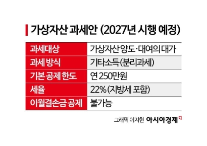 "Stocks Are Not Taxed, but Annual Crypto Gains Over 2.5 Million Won to Be Taxed Next Year... Investors Push Back"
- "Not Jealous of Winning the Lottery"... Entire Village Stunned as 200 Million Won Jackpot of Wild Ginseng Cluster Discovered at Jirisan
- "Even With a 90 Million Won Salary and Bonuses, It Doesn’t Feel Like Much"... A Latecomer Rookie Who Beat 70 to 1 Odds [Scientists Are Disappearing] ③
- Supreme Court Orders NH Investment to Pay 7.5 Billion Won to Ottogi... 'Optimus Fund Mis-selling' Confirmed
- "How Did an Employee Who Loved Samsung End Up Like This?"... Past Video of Samsung Electronics Union Chairman Resurfaces
The stationary front precipitation known as the "autumn monsoon," occurring at the end of August, may continue until early September. It is expected to remain over Chungcheong and the southern regions. Climatologically, the North Pacific High contracts southward at the end of August, but if the cold air descending from the north strengthens, a stationary front forms, causing heavy rainfall. The Korea Meteorological Administration explains that this is not an unusual phenomenon. The temperature at the end of August is also influenced by the extent of the North Pacific High.
© The Asia Business Daily(www.asiae.co.kr). All rights reserved.