Tomorrow's Weather, Return to Average Temperatures... Daytime Highs -1 to 6 Degrees

On the 6th, when the Arctic cold wave arrived, office workers are heading to work wearing thick coats at Sejongno Intersection, Jongno-gu, Seoul. Photo by Kang Jin-hyung aymsdream@
View original image[Asia Economy Reporter Hwang Yoon-joo] On Tuesday the 12th, daytime temperatures will return to average levels. The nationwide morning low temperatures will range from -16 to -2 degrees Celsius, similar to the previous day (-17.8 to -1.1 degrees), but the daytime high temperatures are forecasted to rise slightly to between -1 and 6 degrees Celsius.
The Korea Meteorological Administration expects that, except for inland Gangwon Province, daytime temperatures will rise above freezing in most areas, leading to the lifting of cold wave warnings and a warming trend. Snow flurries are expected briefly before dawn in Seoul, southern Gyeonggi, northern Gangwon Yeongseo, inland Chungnam, and inland Honam, with snow flurries continuing during the day in northern Gyeonggi.
In Jeju Island, rain that began Monday night is expected to continue until the morning with 5 to 10 mm of precipitation. Some mountainous areas may receive 5 to 15 cm of snow.
Due to the influence of a developed low cloud band caused by warm westerly winds, 1 to 5 cm of snow is expected from afternoon to night in Gangwon Yeongseo, Chungbuk, northern inland Gyeongbuk, and Gyeongbuk mountainous areas.
Additionally, southern and eastern Gyeonggi and Chungnam are forecasted to receive around 1 cm of snow or less than 5 mm of rain, while snow flurries are expected in Seoul and southern inland regions.
Fine dust concentrations are expected to be 'bad' in southern Gyeonggi, Sejong, Chungbuk, and Chungnam, while other regions will have 'moderate' levels. Seoul, northern Gyeonggi, Gwangju, and Jeonbuk may experience temporarily 'bad' levels overnight.
The National Institute of Environmental Research’s Air Quality Integrated Forecast Center stated, "In western regions, stagnant air in the morning will cause accumulation of domestically generated fine dust, and at night, inflow of foreign fine dust will raise concentrations."
Dry weather will continue in the East Coast, Gangwon mountainous areas, some Yeongnam regions where dry weather warnings are in effect, as well as in central regions, so caution is advised to prevent wildfires and other fire hazards.
Sea waves will be 0.5 to 1.5 meters in the East Sea and West Sea coastal waters, and 0.5 to 1 meter in the South Sea coastal waters. Offshore wave heights are expected to be 1 to 2 meters in the East Sea, 0.5 to 2 meters in the West Sea, and 0.5 to 2.5 meters in the South Sea.
Hot Picks Today
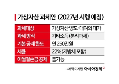 "Stocks Are Not Taxed, but Annual Crypto Gains Over 2.5 Million Won to Be Taxed Next Year... Investors Push Back"
- "Not Jealous of Winning the Lottery"... Entire Village Stunned as 200 Million Won Jackpot of Wild Ginseng Cluster Discovered at Jirisan
- "Rather Than Endure a 1.5 Million KRW Stipend, I'd Rather Earn 500 Million in the U.S." Top Talent from SNU and KAIST Are Leaving [Scientists Are Disappearing] ①
- "How Did an Employee Who Loved Samsung End Up Like This?"... Past Video of Samsung Electronics Union Chairman Resurfaces
- "Even With a 90 Million Won Salary and Bonuses, It Doesn’t Feel Like Much"... A Latecomer Rookie Who Beat 70 to 1 Odds [Scientists Are Disappearing] ③
© The Asia Business Daily(www.asiae.co.kr). All rights reserved.