Creating the Most Precise Map... Ulsan City Selected for High-Precision Electronic Map Construction Project Competition
Ministry of Land Public Project Secures 1.75 Billion KRW in National Funding
Establishing Detailed Maps Across Entire City Including Development Restriction Zones
Ulsan City has been selected for the Ministry of Land, Infrastructure and Transport’s ‘High-Precision Electronic Map Construction Contest Project,’ securing 1.75 billion KRW in national funding.
The high-precision electronic map construction project is one of the national agenda tasks, aimed at producing large-scale digital topographic maps (1:1000 scale digital topographic maps) necessary for data-driven administrative work and private sector use.
“Large-scale digital topographic maps” digitally represent various information such as roads, buildings, rivers, manholes, streetlights, utility poles, traffic lights, and crosswalks using symbols, characters, and attributes according to a fixed scale, covering both artificial structures and natural terrain. These are the most precise digital maps produced domestically.
Following the selection in this contest, Ulsan City will promote the project “High-Precision Electronic Map Construction for the Completion of Digital Twin Ulsan.” By the end of this year, a total of 3.5 billion KRW will be invested to produce digital topographic maps based on aerial photographs for approximately 183㎢ of Ulsan’s development-restricted zones and major development project sites.
Through this project, data foundations for various administrative and private sector uses will be established by utilizing aerial photography, drones, LiDAR, and Mobile Mapping Systems (MMS) to build digital elevation models, precise road maps, and 3D models of buildings and trees, enabling tasks such as design and automatic detection of urban changes.
Hot Picks Today
 600 Million vs. 460 Million vs. 160 Million... Samsung Electronics DS Division: "Three Paychecks Under One Roof"
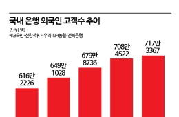
- Opening a Bank Account in Korea Is Too Difficult..."Over 150,000 Won in Notarization Fees Just for a Child's Account and Debit Card" [Foreigner K-Finance Status]②
- [Breaking] KOSPI Triggers Buy-Sidecar... Early Session Recovers 7,500 Mark
- "Disappointing Results: 80% of Sunscreens Found Lacking in Safety and Effectiveness"
- "Who Is Visiting Japan These Days?" The Once-Crowded Tourist Spots Empty Out... What's Happening?
An official from Ulsan City stated, “Ulsan City has been selected for the Ministry of Land, Infrastructure and Transport’s Digital Twin contest project for three consecutive years, growing into a smart city leading digital twin technology. We expect that this contest project will contribute to improving citizens’ convenience and the quality of administrative services through the convergence and fusion of spatial information technology.”

© The Asia Business Daily(www.asiae.co.kr). All rights reserved.
!["Please Help Us": How Much Do Those Bowing Deeply for Your Vote Really Earn? [Data Pick]](https://cwcontent.asiae.co.kr/asiaresize/307/2026052010120870131_1779239528.png)